The Age
The Victorian government wants to flood nine wetlands along the Murray using levees and pumps. Opponents say it is a thinly veiled bid to get out of restoring the river’s environmental flows.WHAT IS THE GOVERNMENT PROPOSING?
There are 9 projects being proposed right now on the Murray River, branded as the Victorian Murray Floodplain Restoration Projects (VMFRP).
They stretch from Gunbower National Park to Nyah-Vinifera, Hattah Lakes and Lindsay and Wallpolla Islands near the South Australian border.
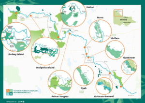
Credit: VFMRP, 2019b
These complex ecosystems have adapted over tens of thousands of years to the natural ebbs and flows of flood waters. They’re biodiversity hotspots that support hundreds of species of birds, fish and plants. But the Victorian government’s dubious idea is that this habitat can simply be “re-engineered” to survive with less water – using concrete walls and pipes instead. It’s as risky as it sounds, and the science has never been tested.
The plan is to cut down hundreds of big old trees to make way for the infrastructure, which will send in just enough water to keep select parts of the floodplain on life support. While some river red gums will be given the water they need, other habitats may be completely drowned. Some places will miss out on getting water at all. These projects will turn dynamic mosaics of floodplain habitat into big irrigation bays.
But that’s not the worst part. The government then wants to use the “water savings” from these projects to justify not giving water to other parts of the river system – a whopping 605 billion litres. Instead of this water flowing to the river, when waterbirds and communities downstream need it, it will be kept in the accounts of the wealthiest corporate irrigators! Read more about how the offset works here >>
Right now, these projects are being formally reviewed for their environmental impacts. The government is trying to spin them as “climate resilience” that will benefit the wetlands. But its blatant greenwashing.
We need to hold our government to account and expose these projects for what they are. Importantly, we need to make sure they’re not used as an excuse to justify depriving rivers of water they desperately need!
Find out how you can get involved
Why is this “water offset” so dodgy?
The Victorian and NSW governments argue that engineering projects can achieve “equivalent” results for our wetlands with less water, using pipes, pumps and levees. Because of this, they want to attach an “offset” so that they don’t have to return as much water to the river as was promised in the Murray-Darling Basin Plan.
It’s based on a dodgy scientific method that’s been slammed by experts and never actually tested in the real world. In fact, when it was subject to scrutiny in the South Australian Royal Commission, the Commissioner described the method as ‘experimental and unprecedented’ with ‘alarming shortcomings.’
It works by using modelling to assess ‘environmental equivalence’ – basically, how many fish, birds, frogs and trees could you keep alive with 36 projects across the entire Basin? Then it models how much water the river would need to do it without those interventions. The difference becomes ‘water savings’ – not to benefit the river, but to stay in the accounts of the biggest irrigators.
If all these projects are awarded an offset, they’d take 605 billion litres away from the river – more than what’s in Sydney Harbour. This water is vital for our rivers’ health and it should be non-negotiable!
These offsets are more like a sneaky accounting trick than actual science, so it’s no surprise there are major problems. These include:
- No modelling on how withholding an extra 605 billion litres of water affects the rest of the Murray-Darling system – particularly fragile ecosystems downstream like the Coorong
- The risks of the engineering works aren’t considered – like how artificially flooding wetlands could favour invasive fish like carp, or degrade important habitat for wildlife
- The impact of a hotter, drier climate isn’t factored into the offset amount – like long-term trends that show decreased rainfall
- The modelling relies on the success of other projects to restore some natural flows – which the Victorian government has dragged for years behind the track
WHAT IMPACT WILL THEY HAVE ON OUR WETLANDS AND RIVERS?
Local impacts from construction
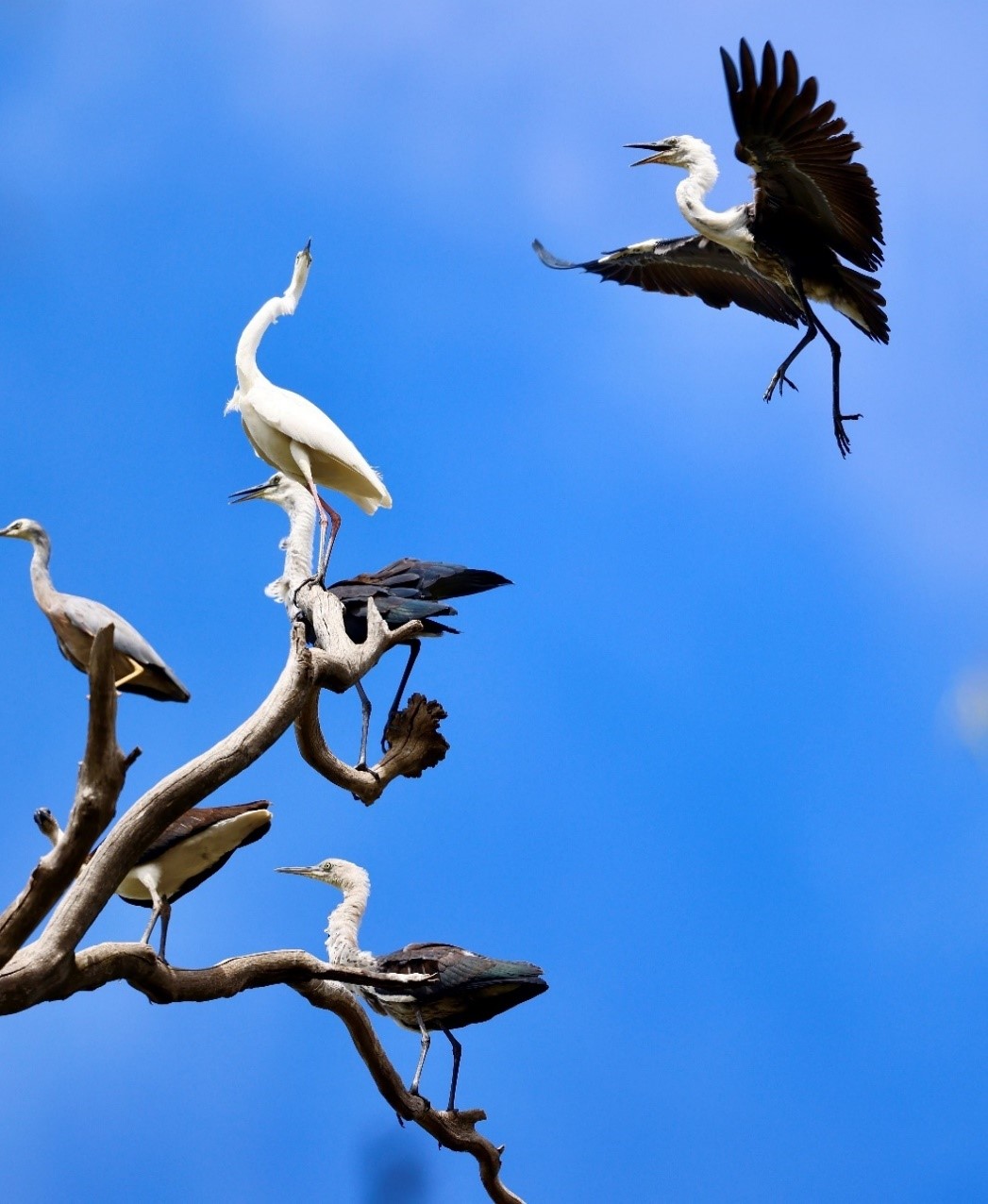
Eastern Great Egret, White-necked Herons and White-faced Heron in thewetlands of Gunbower Forest. Credit Damien Cook Wetland Revival Trust
Floodplain topography formed over thousands of years, with subtle impressions and channels. It’s a landscape where water sits, moves and drains in unique ways. That variation in the terrain supports a mosaic of habitat – making them biodiversity hotspots.
Replacing the natural flow of water with pipes and concrete would turn these unique places into a series of irrigation bays. When water ponds in specific spots instead of flowing naturally across the floodplain, it changes what plants and fish can survive there. Ponding also favours invasive fish species like carp.
On top of this, hundreds of old trees that provide hollows for birds like the Regent Parrot would need to be cut down to build the infrastructure.
Each site is different, with its own specific risks and potential benefits. But they will alter the local ecology, sometimes dramatically.
Indirect impacts to places that won’t get water
These projects will siphon water to 9 sites. But what about everywhere else?
The whole river system needs enough water set aside – that’s the whole point of the Murray-Darling Basin Plan. Allowing 605 billion litres to go to irrigators instead of the river could do serious damage.
If our governments really want to restore our wetlands, the most important solution is keeping enough water in the river and ensuring it can flow to the places that need it most. That means recovering the FULL amount of water in the Basin Plan, using methods we know actually work like water buybacks, and working with landowners to let water flow over their property and onto the floodplain. Research shows that if we set aside water for the environment and let it flow, we could inundate an additional 375,000 hectares of wetlands.
Problems with consultation
The Murray-Darling won’t survive if we treat it as a series of seperate museum pieces. That’s because it’s an interconnected system.
But these projects double-down on that toxic approach. Hand-picked portions of the floodplain will receive life support. Other places will suffer. It’s greenwashing covering up triage.
Critically, some of these issues have been difficult for locals to get answers on. In formal terms, they sit outside the terms of reference.
Going against the flow: the plan to engineer Victoria’s wetlands
WHERE DO THESE FIT IN THE MURRAY-DARLING BASIN PLAN?
At the Basin Plan’s outset, it set a target of returning 3,200 billion litres of water to our rivers. That’s about six times the size of Sydney Harbour, but less than half of what the river needs for a good chance of survival. For all its flaws, it still set in motion the ambitious goal of setting aside enough water to keep the river alive.
But since the beginning, the plan has suffered from a punishing lobbying effort by powerful corporate interests who want to keep taking too much water out of the river. And governments have buckled under the pressure.
The last 10 years have seen Victoria and NSW governments dodge responsibility, ignore the science, push back key Basin Plan deadlines and undermine efforts to recover the water our rivers need. These water offsetting projects are their latest delay tactic.
A convoluted loophole in the Basin Plan means that nearly 20% of the water that is meant to be recovered for the river can be “offset” – allowing big irrigators to keep taking more than their fair share.
This is where these wetland engineering projects fit into the Plan. They’re “supply” measures within the Sustainable Diversion Limit Adjustment Mechanism (SDLAM). Behind all the government’s jargon, they’re offsets – ‘paper water’ instead of the real thing.
The main reason they were conceived wasn’t to benefit the floodplain. It was cooked up by the Nationals Party 10 years ago, so governments wouldn’t have to recover the full amount of water promised in the Basin Plan!
Ultimately, they let 605 billion litres of water flow to wealthy corporate irrigators – not wetlands.
Tyler Rotche, Environment Victoria
 The Murray Darling Basin Plan is hobbled - it's time for Tanya Plibersek to lead
when is this happening?
The Planning Minister has appointed a committee to evaluate the 9 projects in the Victorian Murray Floodplain Restoration Project (VMFRP) in 4 packages.
With individual Environment Effects Statement (EES) and Environment Report (ER) hearings and roundtables for each package there are going to be plenty of opportunities to get involved, particularly in the first half of this year.
- Hattah Lakes North and Belsar-Yungera (EES)
Submissions: Oct-Nov 2022
Hearing: Jan-Feb 2023 - Vinifera, Nyah and Burra Creek (ER)
Submissions: Jan – Mar 2023
Roundtable: April 2023 - Gunbower, Guttrum and Benwell Forests (ER)
Submissions and Roundtable: Mid-year - Lindsay Island and Wallpolla Island (EES)
Submissions and Hearing: Mid-year